Ground Water GIS Data for Minnesota
Ground Water Home | GIS Data |
Web Applications |
Scientific Reports |
General Info
This webpage contains links to downloadable ground water GIS data for Minnesota. The data is usually accompanied by a report or project on ground water or geology but may be standalone. The page is organized by geographic scope:
State
-
Hydrogeologic Maps of Minnesota (MGS, LMIC)
These maps are part of the MGS "State Map" series; scales are 1:500,000 to 1:1 million.
-
Bedrock Hydrogeology

-
Quaternary Hydrogeology
Geologic classification of the hydrogeologic (water-bearing) units for Quaternary (surficial, unconsolidated) deposits.
-
Bedrock Hydrogeology
-
Ground
Water Provinces (DNR Waters)
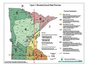
Minnesota has been divided into six ground water provinces based on bedrock and glacial geology that influence ground water availability.
- County Well Index - Well Location Points (MGS, MDH)
Points have been field-verified and digitized or GPS'd. Also see the Minnesota Well Index (MWI).
-
Source Water Protection Maps and Geospatial Data (MDH)
Wellhead protection maps, nitrate probability maps and reports, and geospatial data for topics such as class 5 sensitivity, drinking water supply management areas and their vulnerability, emergency response areas, source water assessment areas, and wellhead protection areas.
-
Ground Water
Contamination Susceptibility in Minnesota (MPCA, LMIC)
A generalized interpretation of ground water contamination susceptibility for the state, based on modeling using data inputs from 40-acre gridcell soil and geology data, with additional geology inputs (note: DNR has posted procedures for determining near-surface pollution sensitivity maps).
-
Water
Use - Water Appropriations Permit Program (DNR Waters)
Water use permit information reports, location map and shapefiles of water appropriation installation locations.
-
Minnesota Groundwater Tracing Database
Collection of dye input points, inferred groundwater flow vectors, descriptive attribute data, and springshed delineations.
-
Minnesota Spring Inventory (DNR)
The project is creating a database and online map of spring locations.
Local/Regional
Selected Counties
-
County Geologic Atlases and Regional Hydrogeologic Assessments
Described on MnGeo's geology information website. See especially "Part B" which covers hydrogeology and ground water sensitivity information.
-
MGS Current Publications
Lists localized studies, maps and reports, some including GIS data.

Twin Cities Metropolitan Area
-
Metropolitan
Area Ground Water Model (Met Council)
The Metro Model is a regional ground water flow model encompassing the Twin Cities seven-county Metropolitan area.
-
Geology
in Support of Groundwater Management for the Northwestern Twin Cities Metropolitan Area
(MGS)
The hydrogeologic investigation focuses on detailed characterization of the Upper Cambrian aquifer commonly referred to as the “Franconia-Ironton/Galesville” or “FIG” aquifer. GIS data includes DEMs of selected bedrock surfaces and shapefiles of bedrock geology, bedrock topography, faults and unit boundaries.
-
Geology in Support of Ground-Water Management for
the Twin Cities Metropolitan Area, Metropolitan Council Water Supply Master Plan
Development - Phase I (MGS)
Information, data and grids describe the subsurface geology and the groundwater recharge potential of a subarea of the glacial geology map.
Southeastern Minnesota
-
Karst Features of Minnesota
Links to karst information are on MnGeo's geology information website.
-
Springshed Mapping (UMN, DNR and local cavers)
Reports and map.
Fargo-Moorhead Region
-
Geological Mapping and
3D Model of Deposits that Host Ground-water Systems in the
Fargo-Moorhead Region, Minnesota and North Dakota (MGS)
This report, accompanying maps and 3D model depict the sediments and rocks that host ground-water systems across this region. GIS data includes point layers for drill holes, geologic material samples and other site information; other layers used to generate surficial and bedrock geology maps; and DEM models of stratigraphic units.
Information Source Abbreviations
DNR = Minnesota Department of Natural Resources (followed by the
division name, e.g., "Waters" for "Division of Waters")
LMIC = Land Management Information Center (now MnGeo)
MDH = Minnesota Department of Health
Met Council = Metropolitan Council of the Twin Cities
MGS = Minnesota Geological Survey
MPCA = Minnesota Pollution Control Agency

