How is aerial photography used in Minnesota?
Aerial imagery taken over Minnesota has been incorporated into a wide variety of projects for decades. In some cases, the availability of imagery makes a project possible; in others, it greatly increases a project's effectiveness or makes it more efficient to complete.
These webpages highlight a sampling of projects. If you have an example that could be added, please contact us at: gisinfo.mngeo@state.mn.us or 651-201-2489.
Natural color imagery
Creating public information websites
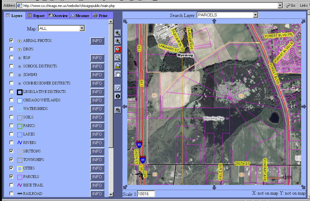 Chisago County's mapping website presents a wealth of data online
to the public. People can view numerous data themes and can choose a
backdrop of either air photos or a topographic map. The photos
provide a real-life view of the landscape that helps to put the other
data, such as parcel boundaries, into context.
Chisago County's mapping website presents a wealth of data online
to the public. People can view numerous data themes and can choose a
backdrop of either air photos or a topographic map. The photos
provide a real-life view of the landscape that helps to put the other
data, such as parcel boundaries, into context.
Click here for more examples of uses of
natural color imagery.
Color-infrared imagery (CIR)
Assessing health of sugar beets
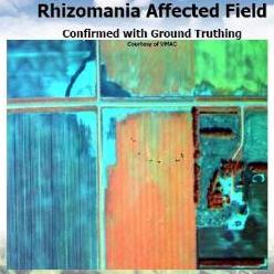 CIR
imagery can help detect plant disease before it becomes visible to the human
eye, enabling farmers to take action earlier and manage production more
effectively. High resolution satellite imagery was used to detect Rhizomania,
a disease that affects sugar beets and other crops. The areas where
Rhizomania was suspected appear green in a field of bright red. Ground
truthing confirmed the presence of the disease. The adjacent fields to the west
appear to have been left fallow or recently plowed based on their blue-green
appearance which indicates the soils may be clayey and have high organic and
moisture content. The imagery was provided by the Upper Midwest
Aerospace Consortium for American Crystal Sugar farmers in northwest Minnesota and North Dakota.
CIR
imagery can help detect plant disease before it becomes visible to the human
eye, enabling farmers to take action earlier and manage production more
effectively. High resolution satellite imagery was used to detect Rhizomania,
a disease that affects sugar beets and other crops. The areas where
Rhizomania was suspected appear green in a field of bright red. Ground
truthing confirmed the presence of the disease. The adjacent fields to the west
appear to have been left fallow or recently plowed based on their blue-green
appearance which indicates the soils may be clayey and have high organic and
moisture content. The imagery was provided by the Upper Midwest
Aerospace Consortium for American Crystal Sugar farmers in northwest Minnesota and North Dakota.
Click here for more examples of uses of color-infrared imagery.
Click on the image for an enlarged view
Related sites
- See Minnesota GIS/LIS News articles for many more applications of NAIP photography:
- Poster: "FSA Air Photos Find Wide Application in Minnesota" (PDF, 5.7MB)
Return to MnGeo's first-stop Aerial Photography page