How are historical geospatial resources used in Minnesota?
Click on any graphic below to see a larger image.
MPCA Citizen Water Quality Monitoring Program

 The Minnesota Pollution Control Agency’s volunteer Citizen Monitoring Program has been actively collecting spatial data for over 20 years and producing annual shapefiles of monitoring locations since 2008.
A spatial archive of this historical annual water quality monitoring information could be used to track the long-term health of Minnesota lakes and streams over time. Monitoring location information could also help determine spatial and temporal data gaps for use in water quality assessments, as well as inform future monitoring strategies.
Check out the Citizen Monitoring Program website to learn more about the wide range of available information, data, and statistics.
Air Photos of Land Use and Survey Boundaries
The fee-to-trust process requires research back in time for what happened on a parcel of land. The Land Information Department with the Fond du Lac Band of Lake Superior Chippewa uses historical photos back to the 1930’s to view changes in vegetation and land use over time. ArcGIS is used to quickly and efficiently view, print, and store an array of aerial photos over time.
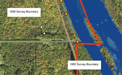 The department also uses historical surveys. The 1854 Treaty creating the Fond du Lac Reservation and the Ceded Territory states that the boundary of the Reservation will begin on an island in the St. Louis River called paw-paw-sco-me-me-tig. Using the 1827 survey by David Thompson, the boundary surveys of 1858 and 1860, and aerial photography from the 1930’s to present, we were able to determine that the island still exists. The 1827, 1858, and 1860 surveys were entered into the GIS and proved to be remarkably accurate considering the mix of technology. See the survey boundaries overlaid on an aerial photo background.
Air Photos of Cultural Resources
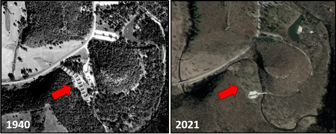 Historical aerial photographs provide a vital view into the past for archaeologists working for state, federal, and tribal governments. These photographs are used to determine the location and condition of historic resources and allow historic preservationists to make informed decisions about how to protect and manage these sites. Often there is little or no above-ground evidence of where these resources are located. For example, buildings may have been demolished and earthworks plowed down.
This historical aerial photograph from 1940 shows the extent of a Civilian Conservation Corps (CCC) camp in Whitewater State Park, compared to what remained in 2021. Historians and archaeologists used this photograph to locate the site of the CCC camp and assess the potential for below-ground resources associated with the camp.
Air Photos of Lake Level Changes
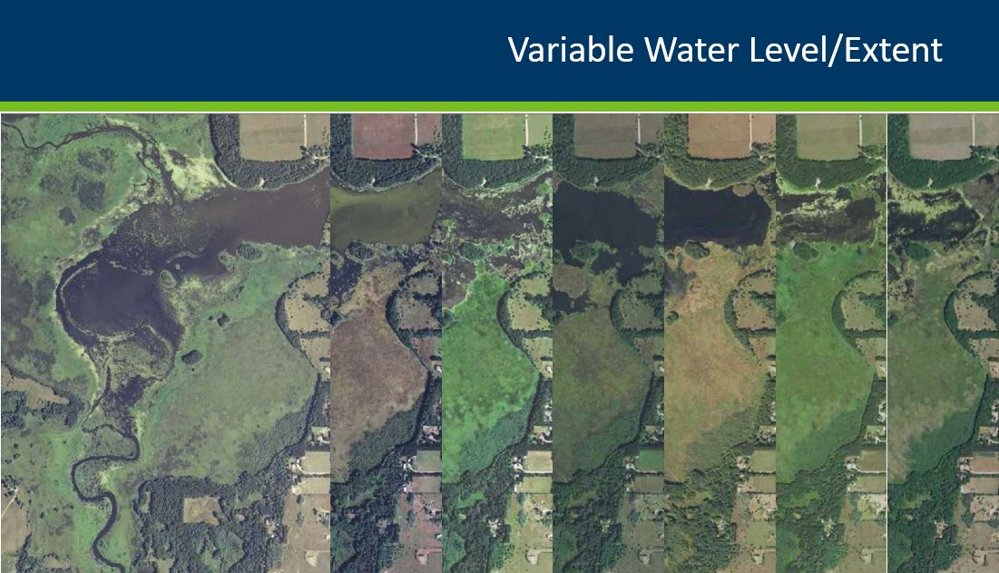
A time series of aerial imagery shows how variable the water level has been for one Minnesota reservoir. Click on the graphic to view an animated PowerPoint slide of Sunrise River Pool #1, near Stacy, showing a sequence of images from 2008, 2010, 2013, 2015, 2017, 2019, and 2021 (run the slide show to see the animation).
Better understanding of lake level changes will improve the results of a multi-year project to update Minnesota’s lakes GIS dataset. This dataset is one of the Department of Natural Resources’ most requested GIS layers. It is used to derive other lake information and is part of several key web applications, such as DNR’s LakeFinder and Watershed Health Assessment Framework. For more information on the project, see Modernizing Minnesota’s Digital Lake Inventory.
Due Diligence for Client Projects
Geospatial data is critical for many companies that do due diligence for private and public entities. Having timely access to all relevant historical data is extremely important (parcels, aerials, environmental data, transportation information, taxation information, etc.). In real estate transactions, the faster you can get the data and analyze it, the more informed and prepared you are for the transaction. Historical digital geospatial data is extremely important in giving clients the best possible service.
For example, if an entity is considering a site for new construction, a Phase I Environmental Site Assessment needs to be completed. In order to do the assessment, the following data layers need to be accurate and accessible: wetlands, parcels (with ownership), zoning, aerial imagery (current and historical), floodplains, railroads, roads, buildings, surveying, and soils. All of this data needs to be analyzed to eliminate unsuitable locations and then a field analysis is performed for the remaining parcels. Often this analysis needs to be performed in a short timeframe.
Having access to this data is very important, not only from a business perspective, but also for the client, for the municipality/township where it would be located, for the area for jobs, and more.
Return to the Archiving Workgroup page