How is aerial photography used in Minnesota?
Natural color photo examples
This webpage provides examples of uses of natural color aerial imagery taken in Minnesota.
Click on any photo below to see a larger image.
Feature location
Mapping gravel pits and water towers
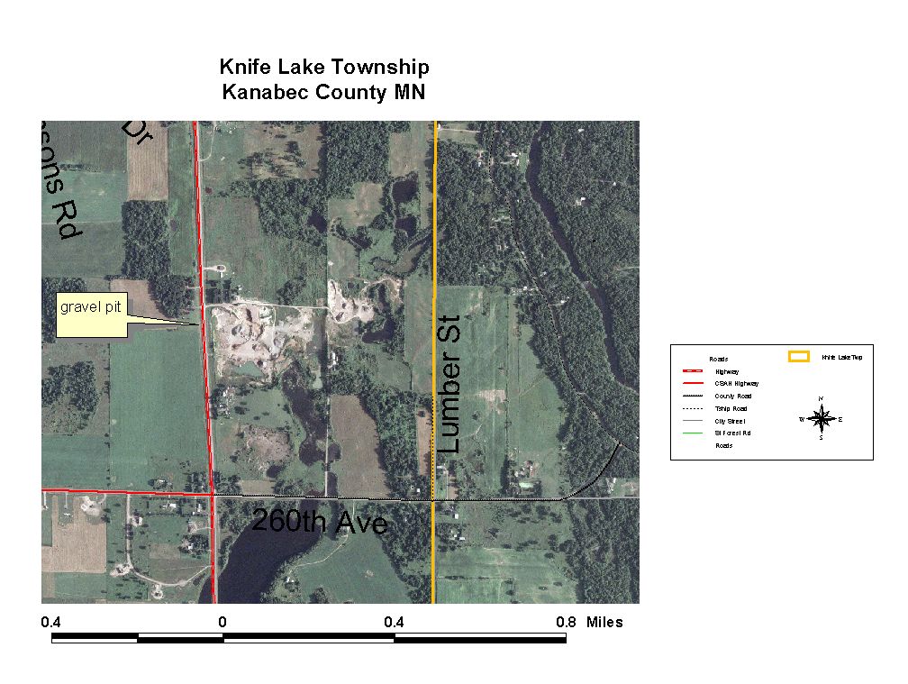
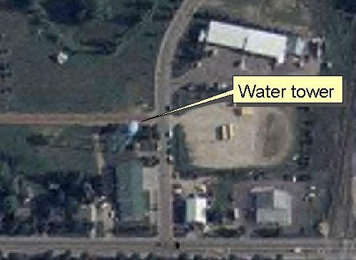 Through photo interpretation, the East Central Regional Development Commission used NAIP photos to locate gravel pits and neighboring homes for use in comprehensive
planning and water towers for use in hazard mitigation planning. The photos saved the one-person staff a tremendous amount of time and travel.
Through photo interpretation, the East Central Regional Development Commission used NAIP photos to locate gravel pits and neighboring homes for use in comprehensive
planning and water towers for use in hazard mitigation planning. The photos saved the one-person staff a tremendous amount of time and travel.
Reference
Creating public information websites
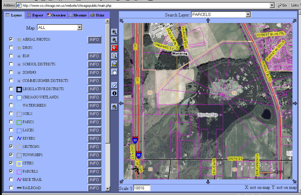 Chisago County's mapping website presents a wealth of data online
to the public. People can view numerous data themes and can choose a backdrop of either the NAIP photos or a topographic map. The photos
provide a real-life view of the landscape that helps to put the other data, such as parcel boundaries, into context.
Chisago County's mapping website presents a wealth of data online
to the public. People can view numerous data themes and can choose a backdrop of either the NAIP photos or a topographic map. The photos
provide a real-life view of the landscape that helps to put the other data, such as parcel boundaries, into context.
Displaying water well information
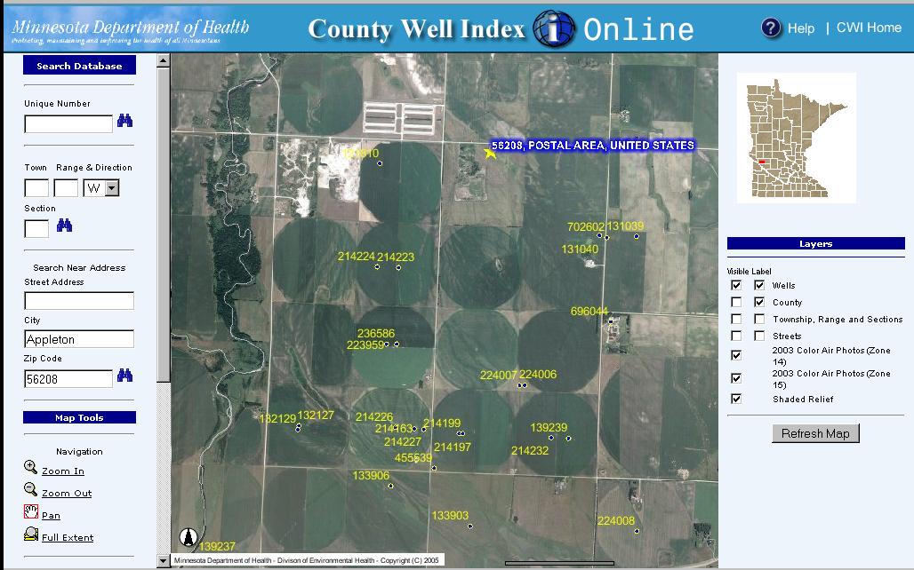 The
Minnesota Well
Index Online website lets the public find out more information about water
wells in their area of interest. Website users can display water wells on a
base map of either NAIP photos (the hybrid base map), a street map or a shaded relief map,
helping them visually identify well locations. They can use the map or a form to
search the well log database for details about well construction and geology.
The site was created by the Minnesota Department of Health (MDH) and serves data
maintained both by MDH and the Minnesota Geological Survey.
The
Minnesota Well
Index Online website lets the public find out more information about water
wells in their area of interest. Website users can display water wells on a
base map of either NAIP photos (the hybrid base map), a street map or a shaded relief map,
helping them visually identify well locations. They can use the map or a form to
search the well log database for details about well construction and geology.
The site was created by the Minnesota Department of Health (MDH) and serves data
maintained both by MDH and the Minnesota Geological Survey.
Displaying agricultural chemical spill investigation information
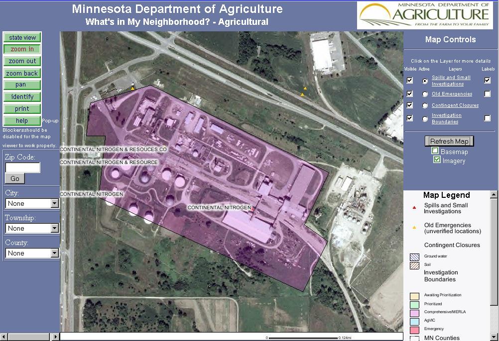 The
What's in My Neighborhood - Agricultural Interactive Mapping website from
the Minnesota Department of Agriculture provides information about agricultural chemical spills that the department tracks. The
website shows boundaries for the approximate extent of large spills and shows
points representing the approximate locations of small spills and of old
emergency sites; users can choose to display NAIP photos in the background to
provide context for the boundaries and points. The website provides additional
information about the accuracy of the locations as well as further details about
both ongoing and completed investigations.
The
What's in My Neighborhood - Agricultural Interactive Mapping website from
the Minnesota Department of Agriculture provides information about agricultural chemical spills that the department tracks. The
website shows boundaries for the approximate extent of large spills and shows
points representing the approximate locations of small spills and of old
emergency sites; users can choose to display NAIP photos in the background to
provide context for the boundaries and points. The website provides additional
information about the accuracy of the locations as well as further details about
both ongoing and completed investigations.
Inventory
Surveying animal populations
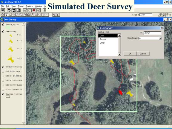 Wildlife
biologists with the Minnesota Department of Natural Resources use NAIP
photos during their aerial surveys of populations of free-ranging
animals such as deer, moose, swan, ring-necked duck and bald eagles. DNR
developed software to integrate GPS and wildlife observation data in
real time displayed on top of the air photos, significantly reducing the
time and money it takes to conduct a survey and manage the resulting
data. For more details, see an
article in the Minnesota GIS/LIS Newsletter, Spring 2006.
Wildlife
biologists with the Minnesota Department of Natural Resources use NAIP
photos during their aerial surveys of populations of free-ranging
animals such as deer, moose, swan, ring-necked duck and bald eagles. DNR
developed software to integrate GPS and wildlife observation data in
real time displayed on top of the air photos, significantly reducing the
time and money it takes to conduct a survey and manage the resulting
data. For more details, see an
article in the Minnesota GIS/LIS Newsletter, Spring 2006.
Combating West Nile virus and encephalitis
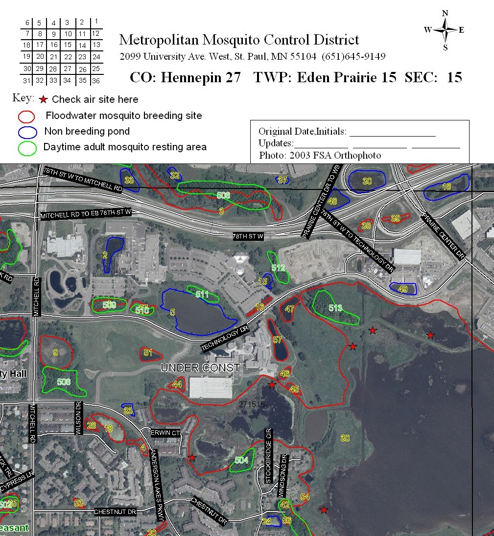 The
Metropolitan Mosquito Control District uses NAIP photos to plan treatments
to control mosquitoes, including those that may carry West Nile virus and LaCrosse encephalitis. Field staff locate wetlands
and plan inspections of yards, parks and woods to find containers and tree holes
that could harbor mosquito larvae; they then also use the photo as a guide when
treating (handy when you're in the middle of a swamp!). Helicopter pilots use
the photos to plan wetland treatment flights. Having recent photos also enables MMCD to update their maps to show wetlands
in new developments and newly created retention ponds.
The
Metropolitan Mosquito Control District uses NAIP photos to plan treatments
to control mosquitoes, including those that may carry West Nile virus and LaCrosse encephalitis. Field staff locate wetlands
and plan inspections of yards, parks and woods to find containers and tree holes
that could harbor mosquito larvae; they then also use the photo as a guide when
treating (handy when you're in the middle of a swamp!). Helicopter pilots use
the photos to plan wetland treatment flights. Having recent photos also enables MMCD to update their maps to show wetlands
in new developments and newly created retention ponds.
Monitoring oak wilt
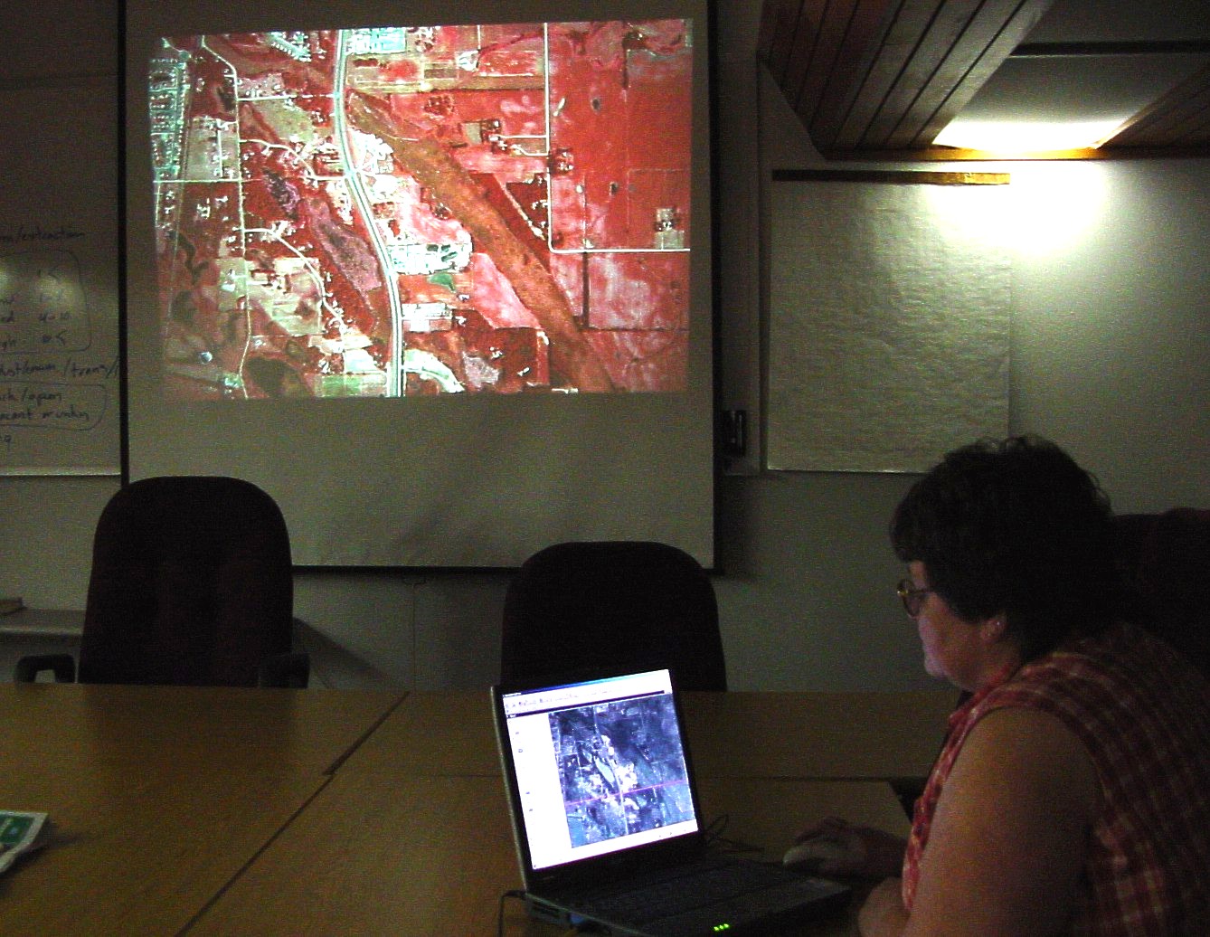 The
Forestry Resource Assessment Unit of the Minnesota Department of Natural Resources
uses NAIP photos as a mapping base for interpreting forest damage. 35mm
color-infrared slides are projected on a movie screen at the largest possible
scale; the staff interpret oak wilt damage visible on the slides and then record
the outlines of the damaged areas by digitizing over NAIP photos. NAIP has
replaced 1991-92 black-and-white photos for this purpose since NAIP is more
recent and since the color provides more information.
The
Forestry Resource Assessment Unit of the Minnesota Department of Natural Resources
uses NAIP photos as a mapping base for interpreting forest damage. 35mm
color-infrared slides are projected on a movie screen at the largest possible
scale; the staff interpret oak wilt damage visible on the slides and then record
the outlines of the damaged areas by digitizing over NAIP photos. NAIP has
replaced 1991-92 black-and-white photos for this purpose since NAIP is more
recent and since the color provides more information.
Inventorying pipeline buffers
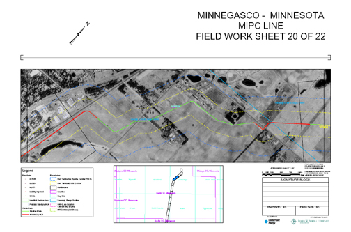
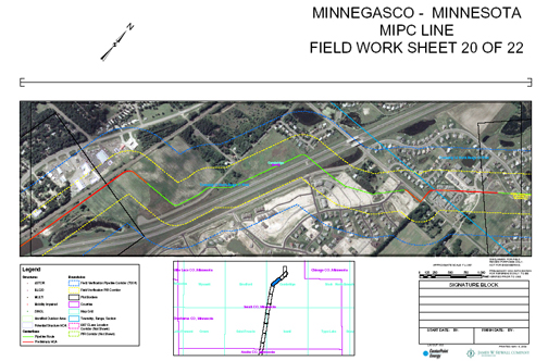 In
order to comply with U.S. Department of Transportation requirements, CenterPoint Energy needs to inventory at-risk populations and facilities within a
specified buffer distance from high-pressure natural gas pipelines. The NAIP
photos have greatly reduced the cost of this process by providing field
inspectors with a current picture of ground conditions.
In
order to comply with U.S. Department of Transportation requirements, CenterPoint Energy needs to inventory at-risk populations and facilities within a
specified buffer distance from high-pressure natural gas pipelines. The NAIP
photos have greatly reduced the cost of this process by providing field
inspectors with a current picture of ground conditions.
These two photos illustrate the extraordinary change that can occur over time. With only the 1991 photo shown above left, inspectors would have
anticipated finding fields; with 2003 data shown above right, they know to expect a major highway and extensive housing developments. (Also see an
article in the Minnesota GIS/LIS Newsletter, Summer 2004.)
Accuracy assessment
Locating parcel boundaries
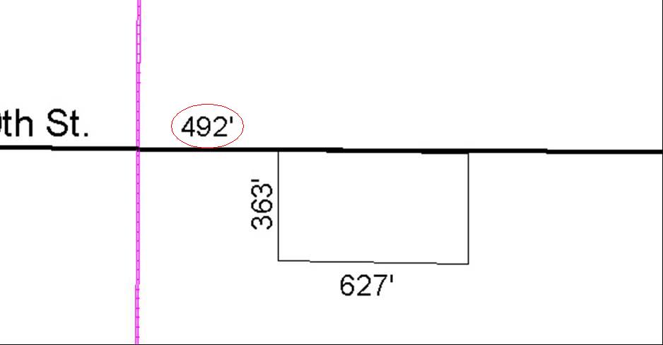
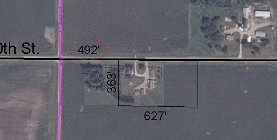
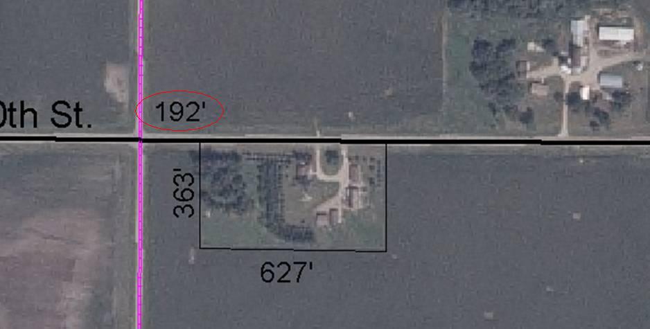 This
parcel in McLeod County was mapped from an old document. The
distance between a section corner and the parcel appeared to be 492 feet.
Registering the parcel layer to the NAIP photo (second graphic), revealed that the parcel
boundary and the land use did not match. The "4" in
the document should actually have been a "1". Once the distance was corrected to 192 feet,
the parcel boundary appeared in the right place (third graphic).
This
parcel in McLeod County was mapped from an old document. The
distance between a section corner and the parcel appeared to be 492 feet.
Registering the parcel layer to the NAIP photo (second graphic), revealed that the parcel
boundary and the land use did not match. The "4" in
the document should actually have been a "1". Once the distance was corrected to 192 feet,
the parcel boundary appeared in the right place (third graphic).
Scenarios
Siting transmission lines
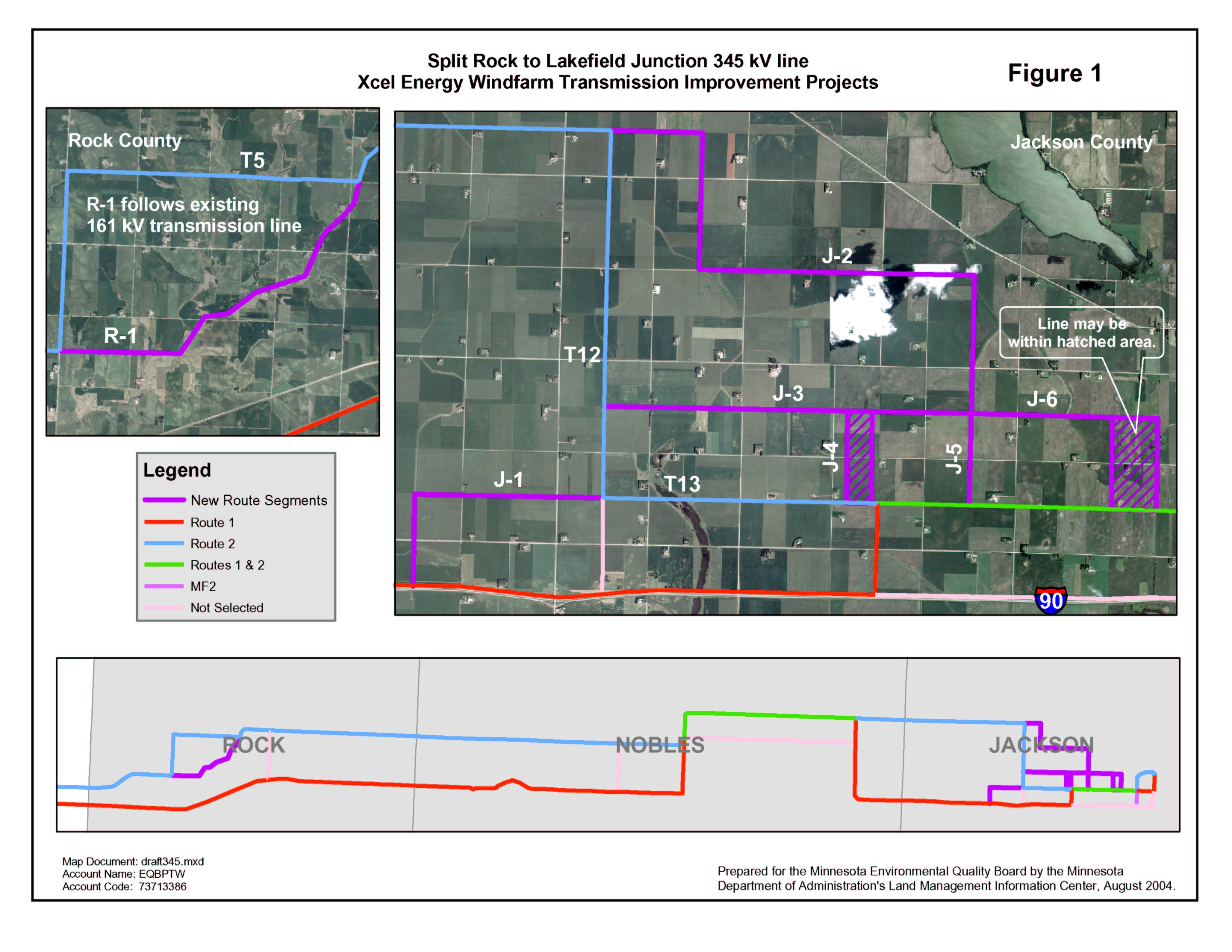 The
Department of Commerce is responsible for permitting new high voltage
transmission line routes in Minnesota. Commerce staff has been relying on maps using
NAIP imagery to show potential transmission line routes at public meetings; the
maps help citizens quickly understand the proposal and provide feedback. The
photos allow for a more complete evaluation process and reduce the chance of
delay in reaching a final decision.
The
Department of Commerce is responsible for permitting new high voltage
transmission line routes in Minnesota. Commerce staff has been relying on maps using
NAIP imagery to show potential transmission line routes at public meetings; the
maps help citizens quickly understand the proposal and provide feedback. The
photos allow for a more complete evaluation process and reduce the chance of
delay in reaching a final decision.
This example shows a portion of a project that will nearly triple the amount of wind power able to be exported from Buffalo Ridge in southwestern Minnesota. The project involves four new power lines that cross six counties in two states.
Marketing
Creating commercial property brochures
 Welsh
Companies, a commercial real estate firm headquartered in Minneapolis, uses NAIP photos to illustrate the location of properties it represents outside the
Twin Cities metropolitan area. They have found that the photos provide a tangibility that no other marketing material provides short of physically
visiting the site.
Welsh
Companies, a commercial real estate firm headquartered in Minneapolis, uses NAIP photos to illustrate the location of properties it represents outside the
Twin Cities metropolitan area. They have found that the photos provide a tangibility that no other marketing material provides short of physically
visiting the site.
Emergency Response
Conducting search and rescue
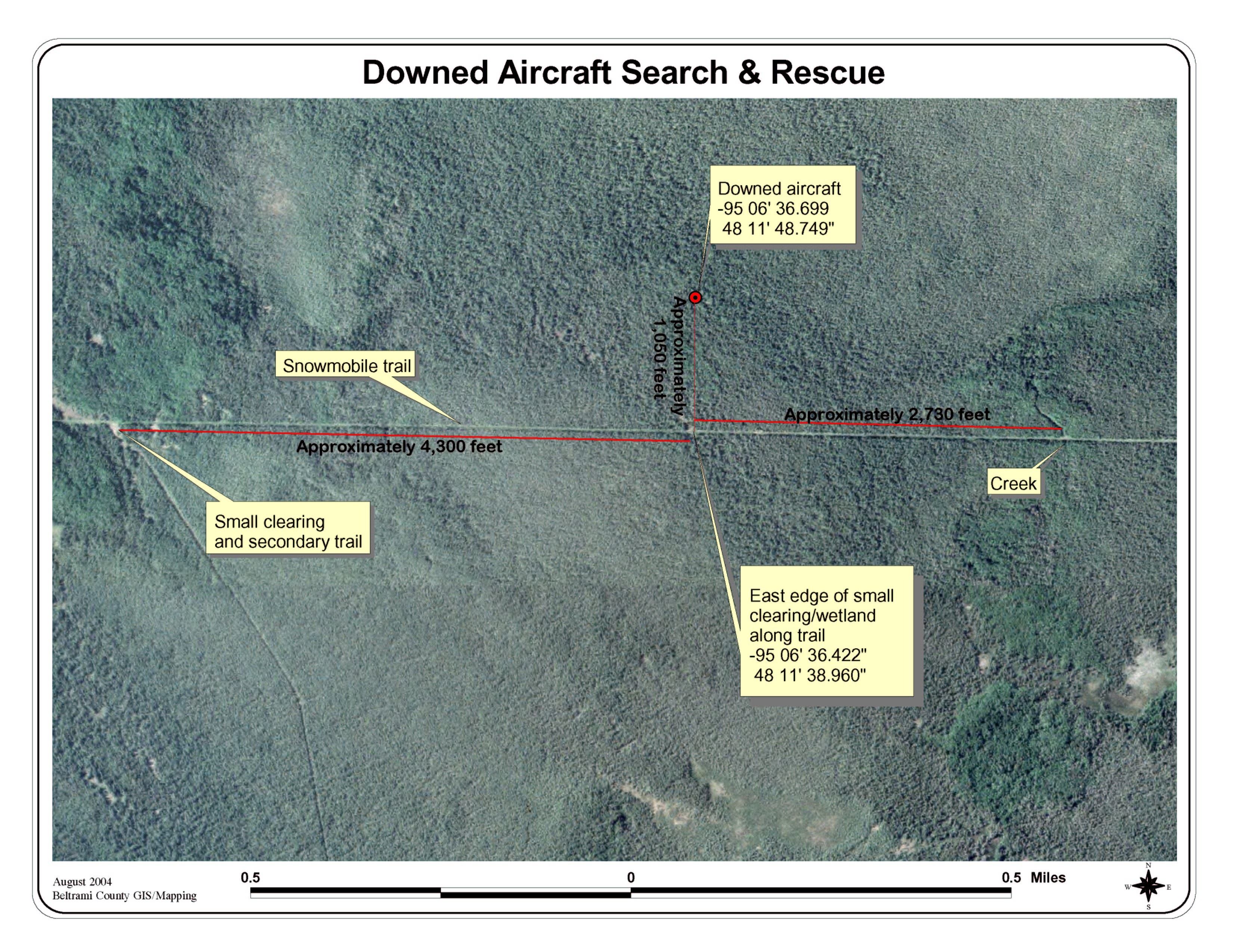 Beltrami
County used NAIP photos to help search for a downed aircraft in a remote part of the county. Obtaining a GPS reading from flight control in Minneapolis, the GIS
team pinpointed the location on the photos and evaluated the terrain around that site. Finding a recognizable location along a snowmobile trail, they got a
bearing and distance from that point to the downed aircraft. The pilot and passengers were rescued unharmed.
Beltrami
County used NAIP photos to help search for a downed aircraft in a remote part of the county. Obtaining a GPS reading from flight control in Minneapolis, the GIS
team pinpointed the location on the photos and evaluated the terrain around that site. Finding a recognizable location along a snowmobile trail, they got a
bearing and distance from that point to the downed aircraft. The pilot and passengers were rescued unharmed.
Return to MnGeo's first-stop Aerial Photography page